
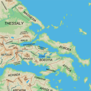
One of the most commonly used facets in environmental engineering is- you guessed it- a base map. A typical base map shows things such as streets, boundaries (country, country, state, city), digital elevation lines, waterways, and aerial or satellite imagery. Pictured below is a standard example of a base map of the Central Regions of Ancient Greece. Boundary lines are pictured in red, and darker greens show higher elevations. (Source: Wikipedia Commons)
The base map is especially relevant to my research because as a part of their curriculum, the students at Wheeler Elementary hope to build a rain garden somewhere on campus. The first step to this process is determining a safe place for the rain garden to be placed.
This is a rough copy of the base map of Wheeler Elementary- Wheeler-BaseMap-Hydrologic Soil Group. (Source: FYRA Engineering). The lines surrounding the school show the elevation, and the closer the lines are together, the steeper the slope. It’s crucial to keep this in mind when picking a place to build the rain garden where the soil is as stable as possible (stability includes factors such as soil density, proneness to slacking, permeability to water, and nutrient content).
My mission for the week is to study the best place for the rain garden to be built, and then design a sort of investigatory curriculum that the students could use to come to the same conclusion.
Of course, the base map is also relevant to the student’s soil testing experiments. When using the soil test kits, the students are looking for a specific type of soil (called A-horizon soil) that exists on a strictly parallel plane. This is because the steep changes in slope could ruin the parallel nature of the soil layer, and mess with the soil stability tests. For that reason, testing soil on as flat a ground as possible is optimal. If you’re curious, last week I wrote a guide to help the students use the soil stability kits (How to- soil stability kits) that will be included in the final curriculum trunk kit.

Cool. Are you learning how to use ArcGIS as well?
LikeLike